Creating Accessibility
The following may be of use for those considering the development of disabled access to sites, to help those looking for design or technical info and information held by a number of organisations
English Heritage produced two guides in 2015, both are available for free, in print and as a PDF download - Easy Access to Historic Buildings and Easy Access to Historic Landscapes - from the English Heritage website
The Fieldfare Trust produced a PDF with the BT Countryside for All Project "Countryside for All Good Practice Guide" this contains useful information for planning and delivering accessibility to sites, it is available to download from our archive ![]()
- This is also available to download from the Paths For All website
Authorising structures (gaps, gates & stiles) on rights of way (DEFRA) - (Archived) - Good practice guidance for local authorities - from the National Archives website
- Archived PDF download - from the National Archives website ![]()
- can also be downloaded from our archive 
Surfacing Guide for Path Projects - Updated - a 2019 "guide to help you choose the most effective and appropriate surfacing material for your path project" - from the Paths for All website
Lowland Path Construction Guide - "Your guide to all aspects of lowland path development and management" from the Paths fro All website
Paths and routes</strong - Guidance on the design of paths and routes. This is a summary of the principle details you should think about when planning, designing or modifying paths and routes. - from the Sensory Trust website
By all reasonable means: least restrictive access guidance - By All Reasonable Means guide contains advice and standards to help owners and managers improve access to countryside and public greenspace. - from the Sensory Trust website
Developing Accessible Play Space: A Good Practice Guide - (Archived) 2003 - The Department for Communities and Local Government - From the National Archive website
Download from the National Archive website ![]()
The Trails Trust produced "Creating Multi-User Public Rights of Way" - A Guide for Local Groups written by Rachel Thompson MBE for The Trails Trust in 2011. About this document - the book was supported by the Department for Environment, Food and Rural Affairs (Defra) and by Natural England. - from the Trails Trust website
Make your business accessible - "Improving your accessibility benefits all customers and does not always require major or expensive changes – simply providing a free Accessibility Guide for your venue can help you be more inclusive for people with a wide range of visible and hidden impairments." - from the Visit Britain website
Visit England - Providing Access for All - has a range of guidance, tools and resources to help you provide access for all, such as - write an Access Statement, Make some quick and low cost improvements and promote your accessibility
Tips on garden design for all disabled gardeners from the Thrive / Carry on Gardening website
Gaps, Gates, Stiles. A guide to the British Standard BS5709:2018 - "Note this is NOT the Standard itself, just a simplified guide to it" - from the Pittecroft Trust website
A few personal thoughts on access
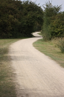
Below are some examples of what to avoid.
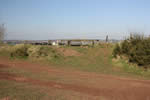
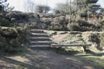
these benches were positioned to offer a wonderful view - unfortunately the less mobile would find it difficult to appreciate this - the first placed on a rise above the path (it could have been gently ramped) - the second steps down from the path to the bench (it could have been set back from the path with level access)
Some positive things to consider - the addition of accessible fishing 'pegs'
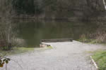
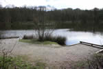
These were taken at a local nature reserve where the council had provided a level well constructed path and fishing positions along one side of a small lake specifically for disabled anglers.
There is usually a need for a gate or some other restriction to prevent livestock from escaping from an area or to prevent unauthorised use such as the riding of motorbikes or horses. Please remember any barrier could also impact on access by wheelchair and mobility scooter users, families with buggies and pushchairs and those who are less mobile. The use of 'accessible gates' with RADAR keys provides one solution however bear in mind that these keys are generally only held by 'Blue Badge' holders, not necessarily all disabled people or families with buggies.
On 'Multi User' trails which generally have been created as cycle routes thought should be given to how wheelchair and mobility scooter users can reach and negotiate the access / exit points. I would also urge the consideration of regular seating, picnic areas having tables accessible by wheelchairs and the height and position of interpretation panels to be accessible. One other thing to think about is the view from a wheelchair, if the trail is bounded by hedges or fences the wheelchair user may well not be able to view any of the surrounding countryside, where possible the provision of vantage points should be considered.
On completion of your accessible site there is one important action which unfortunately is often not treated with due priority - the publication of information about accessibility to the site. I would like to see 'accessibility' info provided on all site descriptions, publications and publicity material as a matter of course - at a minimum a simple "this site is / is not accessible to wheelchair users" statement would be a start. Knowing somewhere is not accessible is sometimes just as useful as knowing it is.
My personal preference is for the following to be published
Wheelchair / Buggy accessible a simple Yes or No - No Wheelchair access but OK for robust buggies.
Gates / Barriers - Details of gates - are they 'accessible kissing gates' are there restriction such as 'not able to take large mobility scooters' or RADAR key required
If RADAR keys are required - is there provision at the site for one to be borrowed?
Type of path surface - tarmac, concrete, natural grass, unmade earth, hoggin, etc. and any issues like 'very muddy in wet weather'
Details of the terrain - gentle slope, generally flat, 1:20 incline over 20 metres, includes short steep section not suitable for manual wheelchair use without assistance, etc.
Distance of accessible section / path - fully accessible 4 miles circular route, 800 metre trail linear route, good path for 3/4 mile then grass for 1 1/2 miles to complete circuit.
To round up - a general description - Accessible trail - 3 mile circular trail, 4 kissing gates (suitable for wheelchairs / buggies but not large mobility scooters) path mainly tarmac or compacted crushed limestone. Generally flat with a gentle rise for 200 metres about half way. Benches every 100 metre for first mile to picnic area ( 2 tables accessible by wheelchairs) occasional seating from then on.
The use of symbols to denote accessible features - I am not a fan of using symbols as a general description. I agree that they are useful on maps and can be of use as a guide on the cover or heading of a leaflet or web description but if used as a general description in place of a narrative then there must be a key and explanation of all the symbols used - and I think if you are going to do that you may as well put in a narrative description, this can always be backed up by symbols if that is part of the 'look and feel' of your design.
Symbols such as the international disabled symbol which is generally understood can be effectively used - however there are many being used that have no recognised meaning and so can be ambiguous or even confusing. I am also sure I have seen a site displaying a wheelchair symbol where the walk started over a stile, I guess the car park and visitor centre was accessible - published material with a good description would leave no doubt about what is and what is not accessible.
One last point - I am a great believer in planners and managers getting first hand knowledge and experience, before embarking on a project I would recommend that the views and suggestions of wheelchair users or user groups be sought. Learn from those who have already completed similar projects, what worked and what didn't.
Now probably my most controversial suggestion, if you are able bodied and responsible for a project to deliver 'accessibility' put yourself in a wheelchair for a day and see how much you learn from the experience, it may just change your perspective. If you are designing a new trail visit one in a wheelchair and see it from that view, see how the access and general design work or don't before you commit to a plan delivered on paper, from an able bodied person that views the world from 2 metres high and has put it together from design guides and specifications sheets. In fact I believe the whole design team would benefit from the experience of viewing a similar project from a wheelchair but that is just my point of view.
I hope the above is useful. Neil Pedley - Accessible Countryside for Everyone
OK how about a test? What is wrong with the following?
OK, on the left a well made path, good surface, no overhanging vegetation, but there is no seating - for families with young children as well as the less mobile seating is important. - On the right a squeeze post - to slow down cyclists I think but no help if you are on a large mobility scooter! (and I did check the gate at the side did not have a RADAR lock)
